Why You Need a Survey WITH a Topo
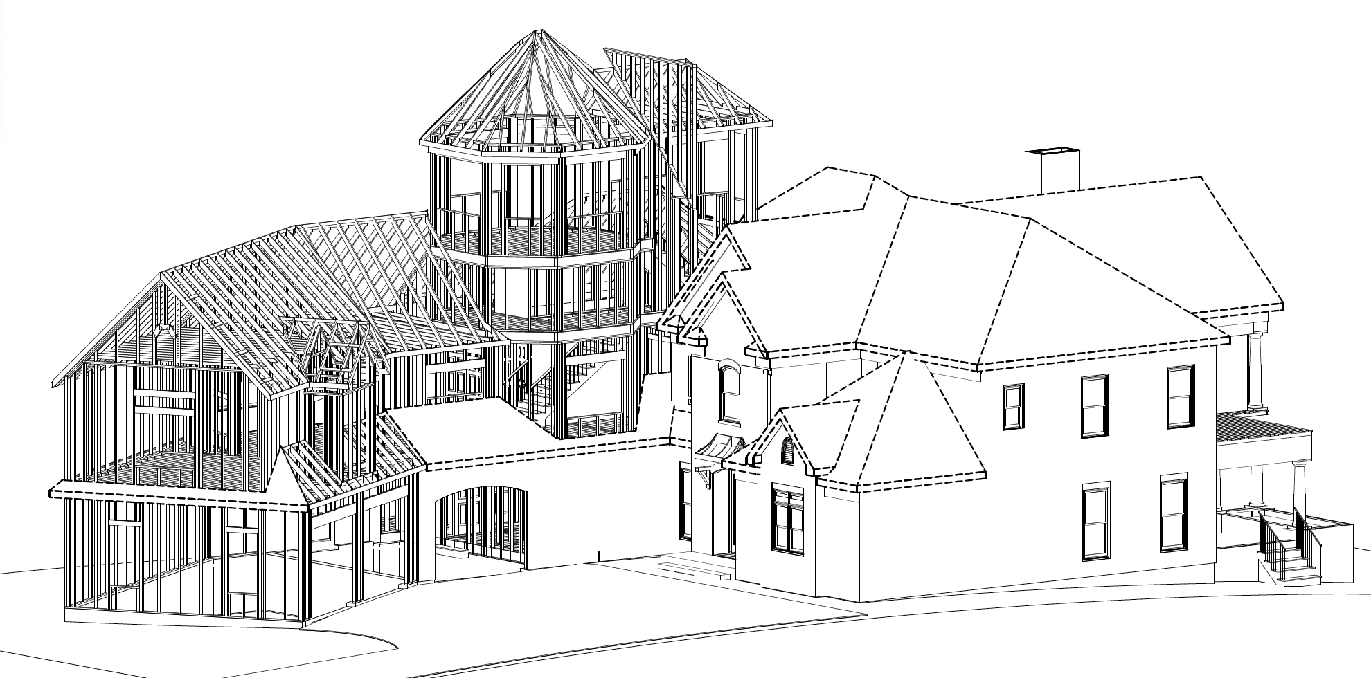
Designing a home is like putting together a puzzle. Some of the most important pieces of the puzzle come from the environment.
Every property is different, and many new homes have challenging building sites, especially those in the lake and mountain areas where we specialize.
Before beginning your design, we need to collect all the data about your specific property. We look at the lay of the land, movement of the sun, seasonal weather patterns, tree coverage, water runoff, and more.
Obtaining all the pieces of the puzzle allows your design to take maximum advantage of potential views, harmonize with the natural beauty of its surroundings, utilize slope to its advantage, and minimize water intrusion.
When your home is complete it should look as though it truly belongs on the site it was designed for.
What is a Survey?
A property survey is a study of the specific property you will be building on. This is needed for all new home designs and additions.
There are essentially 2 different kinds of surveys: boundary surveys and topographical surveys.
Boundary Surveys
A boundary survey plots out the boundary lines of a parcel of land. This sounds pretty straightforward, however there are many boundaries associated with any given property.
In addition to determining where the property begins and where it ends, a boundary survey will also detail setbacks.
What are Setbacks?
A setback is the minimum required distance between your home and each of the following:
- Property lines
- Roadway
- Waterway
- Easement
- Onsite well
- Septic tank
- Drain field
- Detached Outbuildings
Each property has city or county zoning requirements that have established rules for how close a structure can be built in proximity to the aforementioned barriers.
Once all the required setbacks are established for the property, the space left over on the site is called the building envelope, or the buildable area of the land.
Sometimes the legal buildable land is not ideal to build on because of the natural features of the property. A steep slope running across your building envelope, or a deep water runoff gulley running through it can pose serious challenges.
This is where a topo survey is critical.
READ BLOG POST: OVERCOME BUILDING ENVELOPE CHALLENGES
What is a Topo?
Topo is short for topography.
Topography is the study of the natural and artificial features of land surfaces.
The topography of an area refers to the shapes and arrangements of surface features on the ground.
Topographical Survey
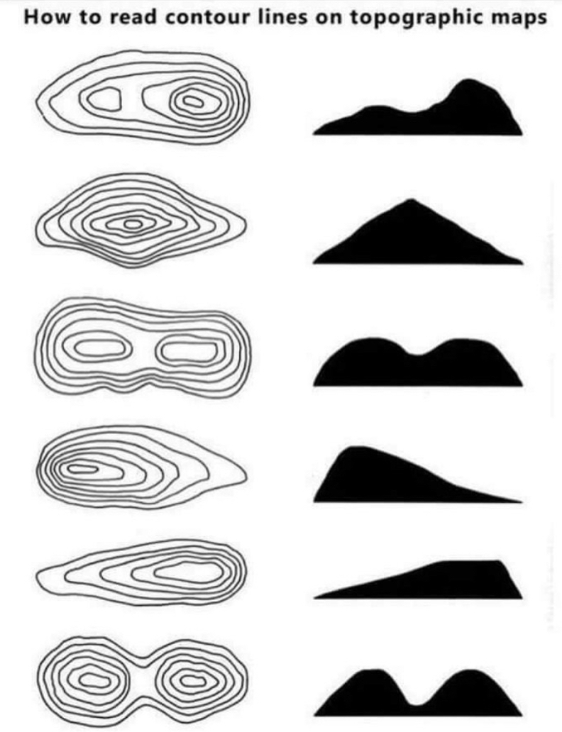
A topographical survey plots the elevations and contours of your property.
Your topographical survey may include some or all of the following information:
- Slopes, hills, valleys, and other changes in elevation
- Streams, rivers, and other water features
- Trees (typically optional and extra – by request)
These surveys mark the difference in elevation of the ground surface using contour lines. Contour lines connect different points of equal elevation to depict slopes, hills, valleys, and other changes in elevation.
Proper use of a topo survey allows us to see how the land looks before plans are drawn. The topography of your property is so important that it can dictate your floor plan, number of levels, room placement, window placement, outdoor living spaces, and more.
A topo survey also helps to identify any areas where construction may be difficult. Intelligent design can actually mitigate construction issues by finding creative solutions to potentially expensive problems.
Topography is vital and cannot be overlooked
when designing and building a home!
What if my lot is flat?
A flat lot may seem easy to design and build on, however one of the biggest challenges to home creation is keeping water away from your foundation. If your property is very flat, water will likely pool around the base of your home. In order to prevent this from happening and to extend the life of your home far into the future we need to know how to design precipitation and water mitigation.
A topo map with close contours will help determine the best location for water runoff mitigation. Sloped grading and swells are created as needed around the home. Downspouts piped underground will direct water away from the foundation.
The Hope and Cross Your Fingers Method
Yes, a property survey with topography included will cost a bit more than one without.
In the past, I’ve had clients skip this extra step and hire us to design their home based only on the boundary survey information and the assumption that their property is flat or only has a gradual slope.
Well, we all know that little saying about assuming, right?
The lay of the land is going to reveal itself eventually. Once the excavators begin moving trees and brush in the building pad area, the exact topography of the land will either be what was anticipated…or it won’t.
Once the builder begins to take grade shots of the site after the clearing and grading has begun, they may find a big surprise. A slope steeper than expected hidden under thick overgrowth or simply a deceiving amount of slope than was assumed is enough to halt construction.
We’ve seen this happen numerous times. If it happens to you, you may be looking at a design that doesn’t exactly work with the lay of the land and your construction team will have to wait for new construction drawings before continuing.
How this small investment up front can save you a lot of money in mistakes later?
Any features not surveyed on a property have the potential to cause costly delays at any stage of development.
Revisions to the designs are much more expensive once in the Construction Drawing Phase, the final phase before construction begins.
The project could end up costing significantly more than originally estimated with revisions that wouldn’t have been needed simply because a topo was not acquired with the survey from the beginning.
We strongly encourage our clients not to gamble with their money. For this reason, we insist that a property survey WITH topographical information be obtained from the very start.
Avoid the frustration of construction delays and unnecessary expenses. Take our advice and expert guidance and obtain all the information necessary to begin the home design journey on the right foot.
NOTE: A topographical survey is not included with a typical boundary survey and must be requested at the time that a boundary survey is ordered.
Our Award-Winning Homes with a View
are designed to fully support your life and those you love!
Give us a call or email us today!